

Send lat and lon together
Includelat and lon on every Site in your sites array. Those two values are what Tread builds the geofence (a virtual fence around a Site) from. Send both or neither.
- Signed decimal degrees. Longitude is negative in North America. No
N/Wsuffixes and no degrees-minutes-seconds. - Six decimal places, maximum. Tread stores six, which is about 4 inches. Extra digits get rounded off, so there’s nothing to gain by sending twelve.
- Numbers, not quoted strings.
pickup and drop_off waypoints. Orders also read staging.
Aim at where trucks stop
The geofence is a circle centered on the exactlat/lon you send. Point it at the scale house, the gate, or the stockpile.
A mailing address or a parcel centroid is the most common reason a fence never triggers. The coordinates land somewhere a truck never parks, so no GPS ping falls inside the circle.
Coordinates beat addresses
Sendlat/lon whenever your source system has them. When a Site arrives with full_address and no coordinates, Tread geocodes the address and accepts the result only when Google returns a ROOFTOP or GEOMETRIC_CENTER match.
Rural quarry and job-site addresses often resolve to RANGE_INTERPOLATED or APPROXIMATE. Tread rejects those on purpose, because a fence in the wrong place is worse than no fence. The Site is created with no coordinates and no geofence.
Two more things worth knowing about the fallback:
- Geocoding runs only when both
latandlonare empty. It never overwrites coordinates you sent. - An address of
UNDEFINEDorUNKNOWNis skipped rather than geocoded. Integrations send these as placeholders.
full_address even when you send coordinates. Tread uses it as the geofence label and for display.
Set the default radius first
With coordinates present, Tread draws a circle centered on them using your company’s default radius. Confirm that default before your first import.1
Open Settings → Configuration
Find the Geofence Creation panel. See Platform Configurations for the rest of the settings on this page.
2
Set Auto Geofence Type to Circle
None stores no default radius, so no geofence gets created — no matter how good your coordinates are. The Radius field only appears once the type is Circle.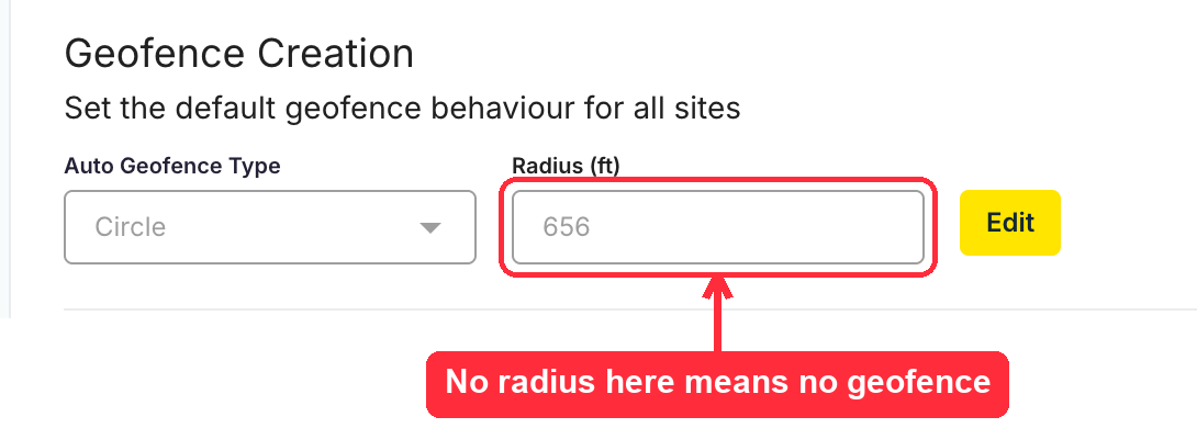
3
Size the radius to the site
The field displays feet or meters based on your company’s unit setting. The API always uses meters.
Cover the working area plus GPS drift. Keep circles of neighboring Sites from overlapping, or arrival and departure attribution gets ambiguous.
Override the radius on one Site
Add anext_billion_geofence object to a Site to override the company default. circle_radius is in meters and must be greater than zero. circle_center defaults to the Site’s lat/lon when you leave it out.
type accepts circle or polygon. Polygons take a geojson object instead of a radius.
Coordinates are set once
A Site that matches an existing record is reused as-is. Tread matches onexternal_id, or on name when the stored Site has no external_id. New lat/lon values in a later payload are ignored.
Get coordinates right on the first import. Corrections after that go through the Tread app or the REST Site endpoint, not the Importer APIs.
Verify after import
A202 Accepted and a processed state don’t prove the Site landed. Check the map instead.
- The Site draws a circle on the Live Map.
- Loads running through it log arrival and departure events.
- A Site that appears on the Project but draws no circle means its coordinates or the default radius failed.
Common pitfalls
- One coordinate without the other drops the Site. No error surfaces on the import record. Send both or neither.
- Auto Geofence Type set to None means no geofence. Perfect coordinates still produce nothing.
- Mailing addresses put the fence in the wrong place. Use the scale house, gate, or stockpile.
- Address-only Sites often get no coordinates. Anything less accurate than
GEOMETRIC_CENTERis rejected, which leaves the Site with no fence. - Re-importing doesn’t fix coordinates. Matched Sites keep the values they were created with.
- Overlapping circles confuse attribution. Tighten the radius or switch to a polygon.
Related
- Importer APIs — the
/ingest/projectsand/ingest/orderspayloads - Sites & Geofences — geofence types, timers, and auto-end behavior
- Platform Configurations — the company-wide geofence defaults
- Onboarding: Sites — setting up Sites in the app
- Paving & Moving Geofences — fences that travel with the work